Victoria
Short-finned eels (Anguilla australis australis) are common in all of Victoria's coastal-draining waterways.1 This note gathers what the literature says about their situation in the state and especially in Melbourne, then turns to futures for the city's waterways. Victoria has no conventional stock assessment for eels,2 so the evidence comes in fragments: fishery records, mortality investigations, telemetry, fish surveys, colonial histories, memoir and Indigenous-led research on drained wetlands. Together these fragments describe a species that supports a commercial fishery, suffers during drought and persists in Melbourne's heavily engineered waterways. For the family Anguillidae in general, see Eel. For eel names in Victorian among other languages, see Eel Names and Languages.
Related Notes
- Eel, Eel Names and Languages, Fish, Water
- Eel Project, Eel Capabilities: Student Brief, Reading List
- Melbourne, Port Philip Bay, Underground, Budj Bim
- Connectivity, Migration, City, Captivity
- Colonialism, Indigenous, Restoration
- Agency, Participation, Law, Artificial Intelligence, AI in Design
- Ladder, Agentic Stair, Design Potential (Private)
Status in Victoria
- Two species. Short-finned eels are common in all coastal-draining waterways, while long-finned eels (A. reinhardtii) occur naturally only east of Melbourne.1 The ranges of the two species overlap across the estuaries and fresh waters on the coastal side of the Great Dividing Range.2
- Indigenous range. Short-finned eels are indigenous to every Victorian river south of the Range, including the Yarra.3
- Conservation status. The IUCN Red List assesses A. australis at species level as Near Threatened, and the species has an estimated generation length of 20 years.4
- Unknown population. The state management plan judges that "the distribution and biology of eels render traditional stock assessment methods inappropriate for the fishery".2
- Episodic recruitment. Large glass eel runs into estuaries are episodic and often follow one or more years of recruitment failure in a catchment.5
- Regional differences. In surveys during the 1990s, glass eels were more abundant in Gippsland than in western Victoria, near the western edge of the species' range. Low catches west of Cape Otway suggested that glass eels may enter these streams less than once a year.5
- Timing of runs. In the Snowy River, glass eels arrived from June to November, with the greatest concentrations from mid-July to late September. The most productive conditions came immediately after new and full moons.5
Fishery, Management and Rights
The 2017 management plan sets the terms for commercial and recreational take of eels in Victoria. The table summarises the settings that matter most for short-finned eels.2
| Setting | Situation under the 2017 plan |
|---|---|
| Origins | The commercial fishery expanded in the 1950s to supply European migrants in Melbourne. |
| Commercial catch | 55.3 to 326.7 t a year between 1978 and 2016 (mean 165.7 t), 84% of it short-finned eels. |
| Stock enhancement | Since the 1960s, fishers have stocked juvenile eels into western Victorian lakes (culture waters) for on-growing. |
| Glass eels | Harvests have had limited success because abundance varies widely. |
| Escapement | At least 30% of connected rivers, creeks and streams with a mouth to the sea stay closed to commercial eel fishing. The listed closures cover about 35.7%. |
| Urban waters | The plan closes waterways mostly surrounded by built-up or urban growth areas. Around Melbourne, closures include the Yarra River, Elwood Canal, the Maribyrnong River catchment, Kororoit Creek, Mordialloc Creek and the Patterson River. |
| Recreational take | 10 eels per person per day, with no size limit. |
| Aboriginal rights | Native title gives Gunaikurnai, Gunditjmara and Wotjobaluk members non-exclusive rights to fish for eels without a licence. The plan commits to joint management with Traditional Owners. |
| Stock assessment | The plan judges traditional stock assessment methods inappropriate for eels. |
Settler Tastes
- Demand from migrants. The commercial fishery expanded in the 1950s to supply European migrants in Melbourne.2
- Disgust in Gippsland. Don Watson's memoir of a 1950s Gippsland childhood records disgust. His grandmother regarded eels as "the real abomination". She landed them only to save her line and tackle. When the family cleaned out its dam, the mud "teemed with fat, metre-long eels", which the eight-year-old Watson killed with a spade.6
- Stewed and smoked in Melbourne. In the twentieth century, poor residents of Collingwood Flat caught Yarra eels and ate them stewed. Later, central European migrants enjoyed them smoked, as the Gunditjmara had done.7
Drought and Die-Offs
Eel die-offs in Victoria coincided with drought, in Melbourne as well as in the western lakes.
- Investigation. From spring 2004, EPA Victoria investigated short-finned eel deaths in 10 water bodies. They included three sub-catchments of the Yarra River and two freshwater lakes in Greater Melbourne.1
- Scale. Most events killed fewer than 100 fish, although the 2004–05 summer brought large deaths at Lake Modewarre and at the Royal Botanic Gardens, Melbourne. Small estuarine deaths since 2004 also included the Yarra. More than 95% of all eel deaths occurred in the stocked lakes of the Western District.1
- Conditions. The common factor in all events was ten years of drought from 1997. Before the deaths, salinity rose by 30 to 40% for three to six weeks, pH exceeded 8.5 and air temperatures reached at least 35 °C. The investigators judged that further information was needed before attributing causality to these factors.1
For die-offs elsewhere, see Die-Offs, Harm and Damage.
Movement and Flows
- Oceanic migration. Eels from south-western Victoria provided the first direct observations of the species' oceanic spawning migration. Researchers attached satellite tags to adult females leaving the Hopkins and Fitzroy rivers.8
- Seasonal departure. At Lake Condah, short-finned eels left mostly in spring, possibly in several phases.9
- Response to flow. In the Moorabool River, environmental freshes from Lal Lal Reservoir raised catches of juvenile short-finned eels moving upstream 26-fold relative to control sites. Environmental flows can therefore support the inland dispersal of recruits.10
For the first two studies, see Agents and Decision-Makers and Budj Bim. For climbing, see Climbing and Overland Movement.
Melbourne
Before and After 1835
Short-finned eels once sustained gatherings, harvests and stone fisheries across the waters that became Melbourne.
- Yarra wetlands. Before colonisation, eels were abundant throughout the Yarra River system.3 Each year they moved up rivers and creeks into the Yarra wetlands, where Aboriginal people gathered to harvest them.11
- Stone fisheries. In 1835, John Batman observed stone eel traps in creeks near Melbourne, with walls "about four feet high" and gates.11
- Creeks. Eels were caught in great quantity in Merri and Mordialloc creeks. Kororoit Creek also provided habitat for short-finned eels.12
- Bolin Bolin. Groups from across the Kulin world gathered at Bolin Bolin Lagoon for weeks each autumn. The historian Mick Woiwod describes the gathering as "made possible by the annual mass migration of the Yarra's short-finned eels out into the ocean". In 1841, a Sydney solicitor bought 5,120 acres of this river frontage under the Special Survey regulations.13
- Muddy Creek. William Barak told of camping at Muddy (Koonung) Creek, which meets the Yarra just downstream of the Bolin Bolin system. The silver eel run turned the place "into a banquet hall". Observers described great piles of eels by the river, feeding hundreds of people for weeks.7
- Tromgin. Downstream, the Tromgin lagoon at what is now the Royal Botanic Gardens "was an important source of eels".14 These wetlands once extended across the Yarra to the present Jolimont rail yards. The Wurundjeri fished for eels there as well as in the billabongs at Bulleen.15 For a Boon Wurrung eel harvest recorded at Tromgin in 1841, see Australian Indigenous Connections in Eel Project.
- A record from 1841. A billabong on the south side of the Yarra let Aboriginal people take eels in large numbers in the right season. In January 1841, George Robinson recorded two Aboriginal men catching about 18 kg of eels there "in a very short time".12
- Nairm coast. Around Nairm (Port Phillip Bay), Boonwurrung people travelling the coast camped at laang tageek baany (rockwells) near Black Rock and Beaumaris. There they tended murnong (yam), caught fish and collected iilk (eel).16
- Swamps. Swamps such as Elwood Swamp supplied plants, wildfowl and eels.17 Leman Swamp in Caulfield also provided eels and fish. Like West Melbourne (Batman's) Swamp, whose site now forms part of Docklands, it was a source of sustenance.7, 18
- Drainage. Colonial urbanisation then drained, filled or channelled these wetlands. Seasonal waterways went into pipes, while lagoons became ornamental lakes.16 Drainage or filling erased Batman's Swamp, while Leman Swamp shrank into what are now the Koornang and Lord Reserves.18 From the Botanic Gardens to Port Phillip Bay, the Yarra now "flows through an almost totally artificial channel".11
- Fish losses. By 1984, only 8 of the Yarra's 14 indigenous fish species were known to remain in the river.3
Eels in the Present City
Eels still live in Melbourne, but the evidence is scattered across fishery rules, ecological surveys, monitoring advice, design projects, a student study and a portrait of the city. The table lists each place with a published record.
| Place | Evidence | Source |
|---|---|---|
| Lower Yarra at Dights Falls | A 3 m weir built in 1895 at the tidal limit is a major barrier to fish moving into the upstream catchment. A fishway (2012, remediated 2020) aims to pass fish of 25 to 400 mm as well as eels up to 1,100 mm. | 19 |
| Yarra tributaries upstream of Dights Falls | Surveys from 2012 to 2017 found short-finned eels common upstream before and after construction of the fishway complex. Eel catch rates gave no sign of an increase, while common galaxias became 7.6 to 28.1 times more abundant. The authors surmise that small eels could already climb the weir before the 2012 fishways. | 20 |
| Dights Falls fishways | The first fishway, built in 1994, performed poorly and was decommissioned within a decade. The 2012 vertical-slot fishway needs monthly debris removal, as well as inspection after floods. | 21 |
| Yarra corridor | Dights Falls is a site of state biological significance with high native fish richness. The Yarra strategic plan lists an effective Dights Falls fishway among the improvements needed for native fish. | 14 |
| Constructed stormwater wetlands, western Melbourne | Short-finned eels occurred at most sites. They had higher δ13C and δ15N values than other fish. The δ13C values suggest a separate carbon source, while the δ15N values suggest a higher trophic position. Exotic species dominated these wetlands. | 22 |
| Streams across greater Melbourne | eDNA metabarcoding detected short-finned eels more readily than backpack electrofishing. Short-finned eels also had the highest false-positive probability of the four species modelled (0.2). | 23 |
| Melbourne Water region | A discussion paper on fish monitoring, prepared for Melbourne Water, lists the short-finned eel as a priority species to target in rivers, wetlands and estuaries. It cites global eel decline as well as anecdotal evidence of decline in Australia. It also notes the species' high cultural and commercial value. | 24 |
| Royal Botanic Gardens | Large eel deaths occurred in the 2004–05 summer. | 1 |
| Rippon Lea Estate | Drain access shafts show "insects and creatures like eels travelling through". | 25 |
| Drains feeding the Yarra | A 2011 portrait of the city states that eels still migrate up the Yarra from the sea, "often finding their way along the various drains that feed into the river". | 15 |
| University of Melbourne, Parkville | Cameras in a stormwater drain and eDNA in campus ponds detected no eels in 2024. | 26 |
| Melbourne Museum, Milarri Pond | About 12 short-finned eels have lived in this exhibit pond for over ten years. | 26 |
| Barak Bridge, Yarra River | Artworks inspired by Indigenous culture include a sculpture based on an eel trap. | 15 |
| Urban waterways | The Yarra River, Elwood Canal, the Maribyrnong River catchment and other urban waters are closed to commercial eel fishing. | 2 |
For the Elizabeth Street story and the campus study, see Eels of Elizabeth Street in Melbourne.
The Birrarung as a Living Entity
- The Act. Wurundjeri Woi-wurrung Elders introduced the Yarra River Protection (Wilip-gin Birrarung murron) Act 2017 into parliament. Its dual Indigenous-language title means "keep the Yarra alive".14
- One living entity. The Act enshrines the protection of the river and its management "as one living and integrated natural entity". It requires a Yarra Strategic Plan to deliver this.14
- Representation without personhood. The Act recognises the river as a living entity while withholding legal personhood. The Birrarung Council, which includes Aboriginal traditional custodians among other representatives, advocates on the river's behalf.27
- Traditional Owner role. The Act gave Wurundjeri Woi-wurrung people a formal process to work with public entities and oversee the governance of the Birrarung.14
- Eels within the entity. On this note's reading, eels form part of the living entity that the Act protects. Their passage and habitat could then count among the river's interests in the council's advocacy.
Gaps in the Evidence
- Passage at Dights Falls. The entrance study measured fishway function through common galaxias, which made up 96% of the 2021–22 catch.19 The catchment-scale study left eels out of its hypotheses because they already lived upstream and can climb vertical structures.20 How young eels pass the weir therefore remains open.
- Drains. The only systematic test of eel movement through inner-city drains found no eels, although its authors note that non-detection does not prove absence.26
- Detection. eDNA could fill this gap, but its false positives for short-finned eels call for confirmation by cameras or capture.23
- Stormwater wetlands. Some stormwater treatment wetlands in Melbourne can be ecological traps for native frogs and fish. Experiments suggest that the dwarf galaxias may choose poorer wetlands as readily as better ones.28 Whether such wetlands trap eels remains untested in the sources reviewed here.
- Silver eels. No source follows silver eels from Melbourne's waterways to the sea.
- Coordinated monitoring. As of 2021, Melbourne lacked a coordinated program to monitor waterway health together with community and Indigenous values.29
Resources for Fieldwork
The resources below could help fieldwork trace where eels lived before the drains, where they move now and where restored creeks could lead them.
-
Lower Moonee Ponds Creek. Ron Barassi Senior Park in Docklands gives access to the lower creek. Upstream, a reach where the concrete channel has been removed allows comparison between engineered and re-naturalised conditions. The Arden Street drain, which feeds the lower reach, approaches 3 m in diameter. For City of Melbourne plans for the creek, see Water Edges.
-
Dights Falls to Richmond on foot. The Imagine the Yarra walk follows the river for 6.3 km, from Dights Falls in Abbotsford to Bridge Road in Richmond. It starts at the weir and its fishway, near the junction with Merri Creek. It then passes Yarra Bend Park, where an unpaved low track follows the riverbank. The route gives access to the weir and the reach below it, where the passage of young eels remains unstudied.
-
Drains known to urban explorers. The Cave Clan, founded in Melbourne in 1986, has charted storm drains across Australia. Its members have explored the ANZAC Drain in South Yarra near Church Street, the main Yarra drain near Como Park and the Maze Drain under Hawthorn. Darmon Richter's illustrated accounts of the ANZAC Drain and the Maze Drain show the conditions an eel would meet. The ANZAC Drain, built in 1910 over a former stream, runs in brick and concrete to a chamber lit from above. The Maze Drain combines narrow pipes, brick chambers and waterfalls of 3 m or more, with large outflows into the Yarra. Signs prohibit entry, so any survey would need permission from the asset owner as well as confined-space procedures.
-
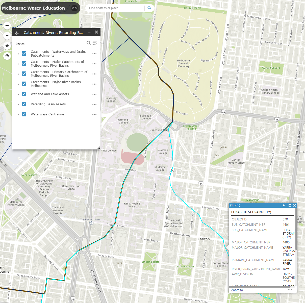
Melbourne Water GIS map. The online map shows catchments, rivers, retarding basins, wetlands, flora and fauna, as well as Registered Aboriginal Parties. It can help select sub-catchments for study. Melbourne Water provides it for education, however, and warns that it may be out of date. In the example below, the map highlights the Elizabeth St Drain (City) sub-catchment, whose boundary crosses the University of Melbourne's Parkville campus.
-
Melbourne Water fish data. A database of in-stream barriers in the Melbourne Water region, compiled in 2017, records their construction and removal over time. Habitat suitability models for native fish inform Melbourne Water's Healthy Waterways Strategy, which sets targets for removing or improving barriers.24
-
City of Melbourne drainpipes. The open dataset maps 17,242 stormwater pipes in the municipality, with material, diameter and year built. Some records lack a diameter. Companion datasets map stormwater pits and litter traps. The pipe data were last updated in November 2022.
-
Before You Dig Australia. A free plan request returns asset owners' plans for a site, including stormwater locations and sizes. The plans also show infrastructure such as gross pollutant traps, at least one of which sits on Moonee Ponds Creek.
-
Automated detection. Eels move mostly when people are absent, so direct observation is rare. Their transparency also makes them hard to detect even with high-resolution cameras.26 Machine learning, combined with ecologists' domain knowledge, can turn large datasets from camera traps and acoustic sensors into ecological information.30 Paired with eDNA, such tools could extend records of eel movement in Melbourne's drains.
Futures for Melbourne's Waterways
Several proposals already imagine how Melbourne's waterways could change. Studies from other cities show what similar changes have meant for eels and streams. The eel-relevant readings below are this note's own unless a footnote supports them.
Existing Proposals for Melbourne
The proposals below differ in standing. Plans and strategies set directions for the agencies that manage the river. Projects and trials change the river itself. Consultation, advocacy and exhibitions shape public expectations, which later plans may adopt. Sources outside the peer-reviewed literature appear as web links.
Plans and Strategies
- From city servicing to city shaping. Waterway management in Melbourne has changed repeatedly over the past fifty years.29 If Melbourne Water keeps responsibility for waterways, it will need to move from a "city servicing" model to a "city shaping" one. That shift would integrate waterway corridors with the city's green spaces, through collaboration with urban planners and Traditional Owners.31 A city-wide network of blue and green corridors could double as a network of eel routes.
- The Yarra Strategic Plan. The plan sets four ten-year performance objectives towards a 50 Year Community Vision for the river.14 Eel passage could become one measure of progress towards that vision.
- Yarra River – Birrarung Strategy. The City of Melbourne endorsed this strategy for the inner-city reach in December 2019. It sets directions for 15 years and names reconciliation with Traditional Owners as a key ambition. The Greenline is one of its key priorities. Young eels bound for the Yarra above Dights Falls must pass through this reach.
- Swimmable Birrarung. The City of Melbourne has signed the Swimmable Cities Charter, which commits it to the long-term ambition of a swimmable river. It plans a coalition with Melbourne Water, the Environment Protection Authority, Parks Victoria and other councils across the catchment. Its stormwater measures include street sweeping, litter traps and water sensitive urban design. New water quality targets and a Stormwater Management Plan will follow. Targets for swimming track risks to human health, so eel needs such as passage through drains would call for measures of their own.
Projects and Trials
- The Greenline. The City of Melbourne's Greenline will transform 4 km of the river's north bank, from Birrarung Marr to the Bolte Bridge, across five precincts. TCL and ASPECT Studios prepared the design ideas. The Falls precinct includes an "ecological river edge" with floating pontoons, as well as new wetland habitat. The River Park precinct adds an ecological wetland. Whether these edges and wetlands serve young eels moving upstream remains open.
- Floating wetlands. The City of Melbourne has installed five floating wetlands along the lower river, as a Greenline trial funded by the Victorian Government. The sites are the Turning Basin at Enterprize Park, the Victoria Harbour Promenade in Docklands and the river near Webb Bridge. The Wurundjeri Narrap team advised on the choice of local indigenous plants. Sunken sections hold aquatic species. Members of the public can record wildlife on the wetlands through iNaturalist. Such records could show whether the submerged parts shelter young eels.
- Re-naturalised creeks. Hoddle's first survey recorded Moonee Ponds Creek as the Monee Monee waterholes, which "billabonged around Flemington and North Melbourne".7 Its partly re-naturalised reach, described under Resources for Fieldwork, offers a local test of how eels respond.
- Private land along the river. Trust for Nature is inviting landholders along the Yarra to protect habitat through conservation covenants. A covenant permanently protects natural features on private land, even after the property is sold. In 2025 the trust planned to contact 50 landholders and visit 20 properties. The Department of Energy, Environment and Climate Action funded the project with $125,000 through the Iconic Urban Waterways Program. Covenants could extend the protection of riverbank habitat for eels to private land.
- Maintenance. Future structures will need upkeep. A 2010 study found that only 7% of 167 Victorian fishways were known to operate effectively, while ownership was unclear for 39%.21
Consultation and Advocacy
- Imagine the Yarra. The Yarra Act requires a community vision for "at least 50 years". From 2017, Melbourne Water ran the Imagine the Yarra consultation to inform it. The consultation gathered 2,500 ideas from 1,200 respondents as videos, drawings, photographs, stories and submissions. A Yarra River Community Assembly of 24 members then drafted the vision with support from river experts and Wurundjeri Elders. The 50-year horizon spans about two and a half eel generations.4 The engagement tools included a walking map, listed under Resources for Fieldwork.
- Birrarung Swimming Trail. Regeneration Projects published the trail in its 2023 Swimmable Cities Handbook. It envisages a corridor of urban swimming places along the lower Yarra. Between Dights Falls and Port Phillip Bay, the river is currently too polluted for swimming. The law also bans swimming there. The campaign aims for a swimmable lower Yarra by 2035. Yarra City Council has signed the Swimmable Cities Charter, as has the City of Melbourne. Cleaner water would serve eels in the same reach. Pools and pontoons along the edge would add structures whose effects on eels remain untested.
Exhibitions and Speculative Design
-
Reimagining Birrarung. The NGV exhibition Reimagining Birrarung: Design Concepts for 2070 (August 2024 to February 2025) asked eight landscape practices to imagine the river in 2070. The NGV developed it with the Birrarung Council, through consultation with Wurundjeri Woi Wurrung Elders. Proposals included turning four golf courses in Kew and Ivanhoe into public wetlands. They also included repurposing drains within the catchment for humans, plants and animals. Another proposed subaquatic drones to monitor water quality. Such proposals could test their wetlands and drains against the needs of migrating eels. ASPECT Studios contributed a historical animation of the river:
-
Future River: When the Past Flows. This exhibition ran at Counihan Gallery in Brunswick, with Blak Dot Gallery, from 3 February to 28 April 2024 as part of PHOTO 2024. Kimba Thompson curated works by Julie Gough, Maree Clarke, Peta Clancy and Jody Haines. Its premise is that "under the cities, the rivers and creeks still flow". The exhibition text adds that waterways "will inevitably run their own course" despite concrete. The premise applies to buried creeks such as Williams Creek under Elizabeth Street.
-
Yarra: Stories of Melbourne's River. The Old Treasury Building presented an exhibition on the river's "turbulent past", with a 47-page catalogue by Margaret Anderson and Ann Wilcox. Its coverage of eels has yet to be checked.
Precedents Elsewhere
None of the studies below comes from Melbourne. The second column names each place so that readers can judge how far a finding transfers.
| Precedent | Where | Finding | Possible relevance to Melbourne | Source |
|---|---|---|---|---|
| Eels in urban streams | Tāmaki Makaurau (Auckland), Aotearoa New Zealand | Tuna (shortfin and longfin eels) were broadly distributed across an urban catchment, with only weak links to particular habitat features. The authors infer that, without movement barriers, tuna can occupy a wide range of urban stream habitats. Their presence may not indicate habitat that supports survival and growth. | Barrier removal may decide whether eels reach Melbourne's urban streams. | 32 |
| Glass eels in a modified catchment | North Sea Canal, Netherlands | Outlets of pumping stations attracted glass eels in proportion to their discharge. Inland barriers delayed glass eels by 4.1 to 13.7 days. | Drain outfalls may draw glass eels into Melbourne's piped network. | 33 |
| Eels at a flood pump | Pump station with a gravity bypass, Aotearoa New Zealand | The gravity bypass was the main route for 332 tagged shortfin eels, and few passed through the pump. Pumps entrained eels mainly in winter and spring, outside the main migration. | Pumps and gates on Melbourne's drains may need provisions for eels moving in both directions all year. | 34 |
| Ramps for elvers | Laboratory trials with elvers from Canterbury rivers, Aotearoa New Zealand | Shortfin elvers climbed best on a moulded plastic drainage product (Miradrain). Success fell as slopes steepened, so the authors recommend about 30° and no more than 50°. | Gives dimensions for eel ramps at weirs, culverts and drain outfalls. | 35 |
| Low-cost climbing aids | Perched culvert, West Coast, Aotearoa New Zealand | Spat ropes and a rubber ramp did not help īnanga or redfin bully pass the culvert. Combined, they moderately helped small banded kōkopu. Eels lived at the site, but the study did not assess them. | Cheap retrofits need testing before they are trusted for eels. | 36 |
| Eel pass model | Modelling study, United Kingdom (European eel) | An individual-based model of elvers in simulated flow through studded eel tiles approximated measured passage better than a cellular automata model. Passage was greatest at shallow slopes, at low discharges and for large elvers. | Simulations based on elver behaviour could test pass designs for Melbourne's weirs and drains. | 37 |
| Deculverting review | Mostly the United States, also the United Kingdom, Canada, Switzerland, Denmark and South Korea | Five projects reported fish returning to deculverted rivers, although the evidence was weak in most cases. | Daylighting may help fish, but monitoring would need to show it. | 38 |
| Daylighting two reaches | Tāmaki Makaurau (Auckland), Aotearoa New Zealand | Invertebrate communities changed by 58% and 71% after daylighting. The authors call for studies of fish. | Buried creeks such as Williams Creek under Elizabeth Street are candidates for similar trials. | 39 |
| Daylighting in two regions | Europe and Asia | High land prices, narrow riparian buffers and resident resistance were the main obstacles. The strongest drivers were economic gains from separating wastewater from rainwater, along with revived cultural links with water. | Offers criteria for choosing which buried Melbourne streams to daylight. | 40 |
For passage designs elsewhere, see Passage Infrastructure.
Eel-Led Design
Design can be defined as "the collective process of creating conditions that support life in response to novel circumstances", which "does not need to involve or be led by humans".41 On this view, eels can contribute to design and lead it. The stair of more-than-human participation, with five questions derived from it, assesses how far a project supports nonhuman leadership.42 The agentic stair restates each step as a check on a directed relation between two agents, such as Melbourne Water toward eels or eels toward a drain. See Ladder, Agentic Stair and Eels as Active Subjects.
| Step and question | Applied to Melbourne's eels | Evidence and gaps |
|---|---|---|
| Recognition: are nonhuman agents recognised as contributors to design? | Do drains, weirs and fishways build on what eels already do, such as climbing wet surfaces or following flow? | Small eels may have climbed Dights Falls before the 2012 fishways.20 Elsewhere, glass eels in the Netherlands followed pumped discharge, while shortfin eels in Aotearoa New Zealand chose a gravity bypass over a pump.33, 34 |
| Solidarity: does the work foster solidarity across species? | Do people and eels share interests in connected, clean waterways? | Waterway corridors already serve the city's liveability.31 No source reviewed here measures what people and eels share. |
| Autonomy: do nonhuman agents have autonomy in the design process? | Do eels' movements change outcomes, through designs or operations that respond to eel behaviour? | Elver climbing trials in Aotearoa New Zealand set ramp angles, and a UK model of elver movement informed pass design.35, 37 Pumps could pause when eels approach, since entrainment at the New Zealand station occurred while pumps ran.34 |
| Conviviality: does the approach support conviviality among diverse life forms? | Can eels coexist with flood control, drainage and recreation when needs conflict? | A flood pump in Aotearoa New Zealand entrained eels outside the migration season.34 Some Melbourne stormwater wetlands may trap native fish.28 |
| Commoning: can design outcomes persist on ecological timescales? | Do institutions keep eel routes open across decades, given a generation length of about 20 years?4 | Victorian fishways often lacked maintenance and clear ownership.21 The Yarra Act and the Birrarung Council offer lasting institutions that could include eels.14, 27 |
- An agentic check at Dights Falls. The agentic stair's autonomy check asks whether outcomes follow B when B's preferences diverge from A's, and whether B can refuse or leave. With Melbourne Water as A and eels as B, eels that climb the weir may already leave the route that people provide.20 The relation reaches autonomy only if fishway operation and future designs then follow what eels do.
- Design potential. A community's design potential is its "ability to sense, absorb, generate, and coordinate variety in order to maintain or transform functions when confronted with novelty".42 Drains that remove alternative routes may reduce this potential for eels even where eels persist. Eel counts alone would miss such losses. See Design Potential (Private).
- Infrastructure. A familiar story of improvement "presumes the superiority of human needs and knowledge", and its common outcome is degraded habitat for many lifeforms. An alternative narrative recognises nonhuman contributions, for example by treating bald cypress trees in the Mississippi River Delta as builders of land.43 Melbourne's drains invite the same reading, with eels as contributors to the design of waterways.
Implications for More-than-Human Design
Melbourne's eels move through infrastructure that people built for drainage, flood control and amenity. The points below draw on the evidence above. Design measures are proposals from this note unless a footnote supports them.
- Urban waters as refuges. The fishery plan already closes Melbourne's urban waterways to commercial eel fishing, which makes them escapement refuges by default.2 Designs for drains, culverts and constructed wetlands could build on that status, for example with climbable surfaces or refuges. Laboratory trials in Aotearoa New Zealand favour ramps near 30° lined with a moulded drainage product. In a field trial there, spat ropes and rubber ramps had limited success for native fish.35, 36
- Timing. Glass eels reached south-eastern Australian estuaries mainly from mid-July to late September in the 1990s surveys.5 Maintenance of estuaries, drains and wetlands could avoid that window. Environmental freshes could instead target it, given the 26-fold response of juvenile eels in the Moorabool River.10
- Monitoring. Pair eDNA with cameras or capture, given the high false-positive rate for short-finned eels in Melbourne streams.23 Fishway monitoring at Dights Falls could record the numbers and sizes of eels. Such records could show whether young eels use the fishway or climb the weir.20
- Hidden waters. Projects at Rippon Lea, on Boonwurrung Country, reconnect visitors with buried waterways through walking, sound and augmented reality.17, 25 Design research can link disciplines around wetlands and make them legible through visualisation.44 Eels that move through these drains could join such projects as participants.
- Country and rights. The fishery plan commits to joint management with Traditional Owners.2 The Yarra Act gives Wurundjeri Woi-wurrung people a formal process to help oversee the river's governance.14 Documented eel places such as Tromgin, Bolin Bolin and the laang tageek baany could guide, under Traditional Owner leadership, which waters receive eel-focused design.13, 14, 16
- Captive and proposed ponds. The Melbourne Museum keeps about 12 eels in an exhibit pond, and the University of Melbourne has considered a campus eel pond.26 Both raise questions about connection to migration routes. They also raise questions about welfare. Cf. Captivity.
Open Questions
- How many short-finned eels live in Melbourne's waterways, and how has that number changed since the 1980s?
- Do young eels pass Dights Falls through the fishway or by climbing the weir itself?
- Would fishway operation at Dights Falls change if eels were shown to bypass it?
- Which inner-city drains, if any, still serve as eel routes?
- Do drain outfalls draw glass eels into Melbourne's piped network, as pumping station outlets do in the Netherlands?
- Do silver eels from urban wetlands reach the sea, and in what condition?
- How could the Birrarung Council represent eels as part of the river's living entity?
- What would joint management of eels look like on Wurundjeri Woi-wurrung and Boonwurrung Country?
References
Footnotes
Leahy, Paul, Alex Leonard, and Renee Johnson. Findings of Western Victorian Lakes Eel Death Investigation 2004–06. Scientific report. Melbourne: Environment Protection Authority Victoria, 2007.˄
Victorian Fisheries Authority. Victorian Eel Fishery Management Plan. Melbourne: Victorian Government, 2017.˄
Glenane, T. J. The Freshwater Fishes of the Yarra River. Melbourne: Melbourne & Metropolitan Board of Works, 1984.˄
Stuart, Rose E., Jason D. Stockwell, and J. Ellen Marsden. “Anguillids: Widely Studied yet Poorly Understood—a Literature Review of the Current State of Anguilla Eel Research.” Reviews in Fish Biology and Fisheries, ahead of print, 2024. https://doi.org/10.1007/s11160-024-09892-w.˄
Gooley, Geoff J., Lachlan J. McKinnon, Brett A. Ingram, B. Larkin, R. O. Collins, and Sena S. de Silva. Assessment of Juvenile Eel Resources in South-Eastern Australia and Associated Development of Intensive Eel Farming for Local Production. Final Report No. 94/067. Alexandra: Marine and Freshwater Resources Institute, 1999.˄
Watson, Don. The Bush. London: Hamish Hamilton, 2017.˄
Otto, Kristin. Yarra: The History of Melbourne’s Murky River. Melbourne: Text, 2011.˄
Koster, Wayne M., Kim Aarestrup, Kim Birnie-Gauvin, Ben Church, David Dawson, Jarod Lyon, Justin O’Connor, et al. “First Tracking of the Oceanic Spawning Migrations of Australasian Short-Finned Eels (Anguilla australis).” Scientific Reports 11, no. 1 (2021): 22976. https://doi.org/10.1038/s41598-021-02325-9.˄
Koster, Wayne, Ben Church, David Crook, David Dawson, Ben Fanson, Justin O’Connor, and Ivor Stuart. “Factors Influencing Migration of Short-Finned Eels (Anguilla australis) over 3 Years from a Wetland System, Lake Condah, South-East Australia, Downstream to the Sea.” Journal of Fish Biology 104, no. 6 (2024): 1824–35. https://doi.org/10.1111/jfb.15726.˄
Amtstaetter, Frank, Zeb Tonkin, Justin P. O’Connor, Ivor Stuart, and Wayne M. Koster. “Environmental Flows Stimulate the Upstream Movement of Juvenile Diadromous Fishes.” Marine & Freshwater Research 72, no. 7 (2021): 1019–26. https://doi.org/10.1071/MF20222.˄
Boyce, James. 1835: The Founding of Melbourne and the Conquest of Australia. 3rd ed. Collingwood: Black Inc., 2013.˄
Presland, Gary. “The Natural History of Melbourne: A Reconstruction.” PhD Thesis, University of Melbourne, 2005.˄
Woiwod, Mick. Forgotten Country: The Hidden Cultural Landscapes of Melbourne’s Middle Yarra: 1837–1851. Kangaroo Ground: Andrew Ross Museum, 2011. Quoted in Lacey, Geoff. “At Home in the Land.” EarthSong Journal: Perspectives in Ecology, Spirituality and Education 2, no. 8 (2014): 21–23. https://doi.org/10.3316/informit.578470409316684.˄
Melbourne Water Corporation. Burndap Birrarung Burndap Umarkoo: Yarra Strategic Plan. A 10-year plan for the Yarra River corridor – 2022 to 2032. Melbourne: Melbourne Water Corporation, 2022.˄
Cunningham, Sophie. Melbourne. Kensington: University of New South Wales Press, 2011.˄
Lara Heyns, Ana, Carolyn Briggs, Brian Martin, Maria de Lourdes Melo Zurita, Laura Harper, and Catherine Murphy. “(Un)Regulated Wetlandscapes – Laang Tageek Baany in Boonwurrung Country, Nairm.” Settler Colonial Studies, 2026, 1–19. https://doi.org/10.1080/2201473X.2026.2619308.˄
Lara Heyns, Ana. “Walking with Water: Reframing Drained Waterways in Melbourne.” Geoforum 159 (2025): 104216. https://doi.org/10.1016/j.geoforum.2025.104216.˄
Giblett, Rod. “Lost and Found Wetlands of Melbourne.” Victorian Historical Journal 87, no. 1 (2016): 134–55.˄
O’Connor, Justin, Matthew Jones, Frank Amtstaetter, Gabriel Cornell, Al Danger, Thomas Ewing, Ben Fanson, and Ivor Stuart. “Remediating a Fishway Entrance to Improve Fish Attraction: A Framework for Success.” Journal of Ecohydraulics 11, no. 1 (2026): 34–44. https://doi.org/10.1080/24705357.2025.2489950.˄
Amtstaetter, Frank, Justin O’Connor, Dan Borg, Lauren Johnson, and Paul Moloney. “Fishways Provide Catchment-Scale Improvements to Common Galaxias (Galaxias maculatus) Upstream of a Barrier in South-Eastern Australia.” New Zealand Journal of Marine and Freshwater Research 58, no. 4 (2024): 591–606. https://doi.org/10.1080/00288330.2023.2287200.˄
Moore, Harriet Elizabeth, and Ian D. Rutherfurd. “Lack of Maintenance Is a Major Challenge for Stream Restoration Projects.” River Research and Applications 33, no. 9 (2017): 1387–99. https://doi.org/10.1002/rra.3188.˄
Mackintosh, Teresa J., Jenny A. Davis, and Ross M. Thompson. “The Effects of Urbanization on Trophic Relationships in Constructed Wetlands.” Freshwater Science 36, no. 1 (2017): 138–50. https://doi.org/10.1086/690674.˄
McColl-Gausden, Emily F., Andrew R. Weeks, Rhys A. Coleman, Katie L. Robinson, Sue Song, Tarmo A. Raadik, and Reid Tingley. “Multispecies Models Reveal That eDNA Metabarcoding Is More Sensitive than Backpack Electrofishing for Conducting Fish Surveys in Freshwater Streams.” Molecular Ecology 30, no. 13 (2021): 3111–26. https://doi.org/10.1111/mec.15644.˄
King, Alison. MERI for Fish of the Melbourne Water Region: A Discussion Paper. Report Prepared for Melbourne Water by the Centre for Freshwater Ecosystems No. 263. Melbourne: La Trobe University, 2020.˄
Briggs, N’Arwee’t Carolyn, Justin Buckley, David Chesworth, Taylor Coyne, Alexis Farr, Laura Harper, Xavier Ho, et al. “Listen - Look up! Listen - Look down! Experiencing the Counter-City through a Sonic and Augmented Reality Experience of Urban Undergrounds in Southeast Melbourne.” Cities 142 (2023): 104513. https://doi.org/10.1016/j.cities.2023.104513.˄
Appleford, Emily, Tilong Huang, and Qingyang Wang. The Urban Eel Odyssey: Tracing Current Migration Pathways through Melbourne’s Storm Drains. No. ENGR90038. Melbourne: University of Melbourne, 2024.˄
Reeves, Jade-Ann, and Timothy D. Peters. “Responding to Anthropocentrism with Anthropocentrism: The Biopolitics of Environmental Personhood.” Griffith Law Review 30, no. 3 (2021): 474–504. https://doi.org/10.1080/10383441.2022.2037882.˄
Hale, Robin, Stephen E. Swearer, Michael Sievers, and Rhys Coleman. “Balancing Biodiversity Outcomes and Pollution Management in Urban Stormwater Treatment Wetlands.” Journal of Environmental Management 233 (2019): 302–7. https://doi.org/10.1016/j.jenvman.2018.12.064.˄
Hart, Barry T., Matt Francey, and Chris Chesterfield. “Management of Urban Waterways in Melbourne, Australia: 1. Current Status.” Australasian Journal of Water Resources 25, no. 2 (2021): 183–201. https://doi.org/10.1080/13241583.2021.1954281.˄
Tuia, Devis, Benjamin Kellenberger, Sara Beery, Blair R. Costelloe, Silvia Zuffi, Benjamin Risse, Alexander Mathis, et al. “Perspectives in Machine Learning for Wildlife Conservation.” Nature Communications 13, no. 1 (2022): 792. https://doi.org/10.1038/s41467-022-27980-y.˄
Hart, Barry T., Matt Francey, Chris Chesterfield, Dom Blackham, and Neil McCarthy. “Management of Urban Waterways in Melbourne, Australia: 2 – Integration and Future Directions.” Australasian Journal of Water Resources 28, no. 1 (2024): 101–22. https://doi.org/10.1080/13241583.2022.2103896.˄
Whitelock, Nicole A., Kevin S. Simon, and George L. W. Perry. “An Urban Taonga: The Distribution and Abundance of Tuna in Urban Streams across Tāmaki Makaurau, Aotearoa-New Zealand.” New Zealand Journal of Marine and Freshwater Research 60, no. 1 (2026): e70010. https://doi.org/10.1002/nzm2.70010.˄
Griffioen, Ben, Thomas Wilkes, Olvin A. van Keeken, Tessa van der Hammen, Anthonie D. Buijse, and Hendrik V. Winter. “Glass Eel Migration in an Urbanized Catchment: An Integral Bottleneck Assessment Using Mark-Recapture.” Movement Ecology 12, no. 1 (2024): 15. https://doi.org/10.1186/s40462-023-00446-6.˄
Mahlum, Shad, Cindy Baker, Mike Lake, Emily White, Alicia Williams, Peter Williams, and Paul Franklin. “The Spatiotemporal Movement Ecology of Shortfin Eels and Entrainment Risk of Yellow Eels at a Flood Relief Pump Station with Gravity Bypass.” Ecological Solutions and Evidence 6, no. 4 (2025): e70130. https://doi.org/10.1002/2688-8319.70130.˄
Jellyman, Phillip G., Joshua T. Bauld, and Shannan K. Crow. “The Effect of Ramp Slope and Surface Type on the Climbing Success of Shortfin Eel (Anguilla australis) Elvers.” Marine & Freshwater Research 68, no. 7 (2017): 1317–24. https://doi.org/10.1071/MF16015.˄
Bowie, Sjaan, Nixie Boddy, Cindy F. Baker, Jonny Horrox, and Paul A. Franklin. “Limited Success of Spat Ropes and Rubber Ramps for Restoring Fish Passage at a Perched Culvert.” New Zealand Journal of Marine and Freshwater Research 60, no. 3 (2026): e70057. https://doi.org/10.1002/nzm2.70057.˄
Padgett, Thomas E., Robert E. Thomas, Duncan J. Borman, and David C. Mould. “Individual-Based Model of Juvenile Eel Movement Parametrized with Computational Fluid Dynamics-Derived Flow Fields Informs Improved Fish Pass Design.” Royal Society Open Science 7, no. 1 (2020): 191505. https://doi.org/10.1098/rsos.191505.˄
Wild, Thomas C., Jacqueline F. Bernet, Emma L. Westling, and David N. Lerner. “Deculverting: Reviewing the Evidence on the ‘Daylighting’ and Restoration of Culverted Rivers.” Water and Environment Journal 25, no. 3 (2011): 412–21. https://doi.org/10.1111/j.1747-6593.2010.00236.x.˄
Neale, Martin W., and Emma R. Moffett. “Re-Engineering Buried Urban Streams: Daylighting Results in Rapid Changes in Stream Invertebrate Communities.” Ecological Engineering 87 (2016): 175–84. https://doi.org/10.1016/j.ecoleng.2015.11.043.˄
Wantzen, Karl M., Téa Piednoir, Yixin Cao, Alvin M. Vazhayil, Chaozhong Tan, Franz Günter Kari, Mirja Lagerström, Nadine V. Gerner, and Mario M. Sommerhäuser. “Back to the Surface – Daylighting Urban Streams in a Global North–South Comparison.” Frontiers in Ecology and Evolution 10 (2022). https://doi.org/10.3389/fevo.2022.838794.˄
Roudavski, Stanislav. “The Ladder of More-than-Human Participation: A Framework for Inclusive Design.” Cultural Science 14, no. 1 (2024): 110–19. https://doi.org/10.2478/csj-2024-0015.˄
Roudavski, Stanislav, and Alexander Holland. “Are You Blocking Nonhuman Leadership? Five Questions to Find Out.” In PDC ’26: Proceedings of the 19th Participatory Design Conference, vol. 2, edited by Laura Galluzzo, Anna Meroni, Daniela Selloni, Davide Fassi, Daniela de Sainz, Andrea Botero, Stefana Broadbent, et al., 372–81. New York: Association for Computing Machinery, 2026. https://doi.org/10.1145/3789492.3796416.˄
Gordon, Bonnie J., and Stanislav Roudavski. “More-than-Human Infrastructure for Just Resilience: Learning from, Working with, and Designing for Bald Cypress Trees (Taxodium distichum) in the Mississippi River Delta.” Global Environment 14, no. 3 (2021): 442–74. https://doi.org/10.3197/ge.2021.140302.˄
Crosby, Alexandra, Sarah-Jane Jones, and Holly O’Neil. “Surfacing Wetlands through Design Ethnography and Critical Visualisation.” In DRS2026: Edinburgh, 8–12 June, Edinburgh, United Kingdom, edited by Luca Simeone, Colin M. Gray, Arno Verhoeven, Amalia de Götzen, Yekta Bakırlıoğlu, Hadas Zohar, Michael Stead, and Peter Buwert. Edinburgh: Design Research Society, 2026. https://doi.org/10.21606/drs.2026.1115.˄
Backlinks