Port Philip Bay
Names
Narrm Narrm or Nairm
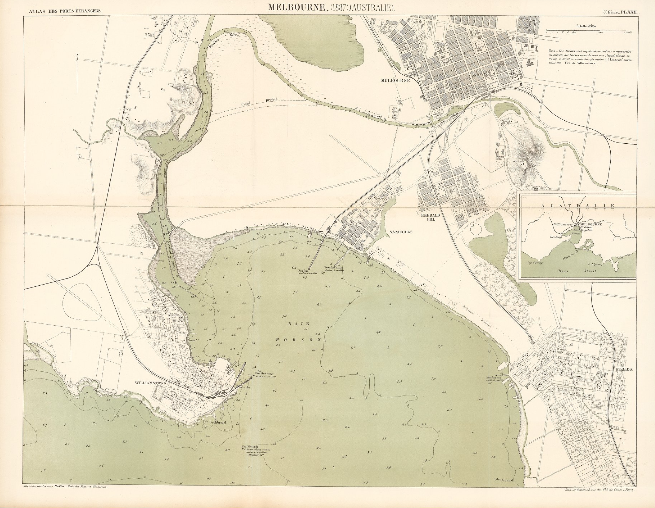
Melbourne. (1887) (Australie). 5e Série. Pl. XXII. Ministère des Travaux Publics. Ecole des Ponts et Chaussées. Lith. A. Simon, 13, R. du Val-de-Grâce. Paris. (David Rumsey Historical Map Collection)
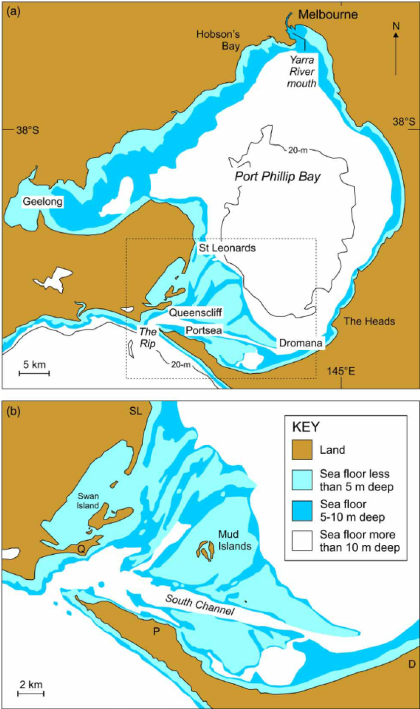
Maps of Port Phillip Bay showing its present form and bathymetry (A) and details of its modern entrance (B) shown by the rectangle in A. Bathymetry is from Australian Hydrographic Service chart Aus143 (May 1973).
Nunn, Patrick D., and Nicholas J. Reid. ‘Aboriginal Memories of Inundation of the Australian Coast Dating from More than 7000 Years Ago’. Australian Geographer 47, no. 1 (2016): 11–47. https://doi.org/10/gfkq2b.
Welcome to Country | Port Phillip & Western Port Regional Catchment Strategy
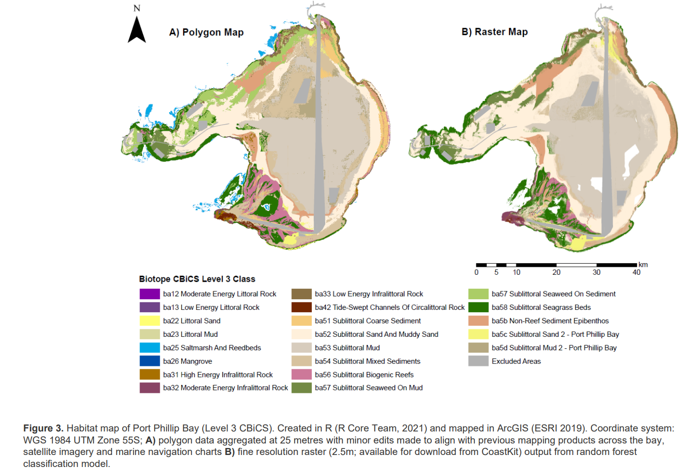
Mazor, Tessa, Matt Edmunds, Adrian Flynn, and Lawrance Ferns. ‘Port Phillip Bay Habitat Map. Habitat Complex Modelling (CBiCS Level 3).’ Melbourne: The State of Victoria Department of Environment, Land, Water and Planning, 2021.
Links
Waterways as bird habitats and places for birdwatching, a page at site of the Healthy Waterways Strategy,a vision for the health of rivers, estuaries and wetlands in the Port Phillip and Westernport region.
Western Treatment Plant virtual tour | Melbourne Water, as a part of an educational initiative about managed water in and around Melbourne.
Waterbirds at the Western Treatment Plant, outcomes of the long-term monitoring.
Interesting Issues
- major environmental changes during log-term human populations
- artificial structures such as wetlands supporting large numbers of birds
- active restoration of water including daylighting of streams and recreation of wetlands
- predicted impact of sea level rise
- Indigenous cultures and land knowledge
- the change in the story of the bay formation, from 10,000 years to 1,000 years, with science following traditional stories, see this.1
- underwater sprawl
- waterfront regeneration
- benefits of the Indigenous management and care (law)
- The Ramsar Convention on Wetlands - DCCEEW
Pairing
Port Philip Bay and Western Port Bay vs Po Delta and the Venice Lagoon. These are two comparable pairs, the same ecological setting, in each geographical region one is more urban/managed and the other is more intact.
Environmental History
Port Phillip Bay, the Yarra River delta, and the surrounding countryside hold a rich environmental and ecological history shaped by geological events, human occupation, and climate changes.
Between 1990 and 2011, Port Phillip Bay experienced two major ecological disturbances: a prolonged drought from 1997–2010; and the introduction of the invasive northern Pacific seastar – a native of the northwest Pacific and a voracious predator which peaked in population at 56% of the resident fish biomass in 2000.
How the bays work | Port Phillip Bay and Western Port
Geological History
Over 400 million years ago, the region was formed by tectonic forces, creating a basin.
Cretaceous period (120 million years ago): The region was underwater during this period, and marine sediment deposits laid the foundation for the Yarra River delta.
Eocene epoch (40-50 million years ago): The sea retreated, and the region began to take its current form.
Quaternary period (2.6 million years ago to present): The period saw multiple glaciations, which caused significant changes in sea levels.
Sea level rise (8,000-10,000 years ago): The last major sea level rise filled the basin, forming Port Phillip Bay.
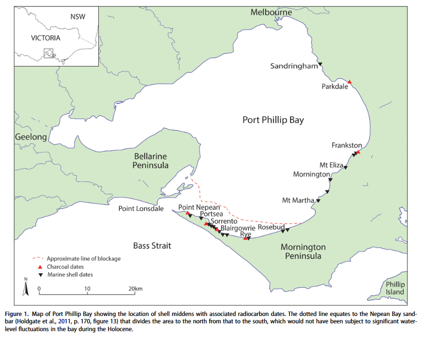
Frankel, David, David C. Thomas, Rebekah Kurpiel, Caroline Spry, Jacqueline Tumney, Lorena Becerra-Valdivia, and Bunurong Land Council Aboriginal Corporation. ‘Late Holocene Drying of Port Phillip Bay: Archaeological and Cultural Perspectives’. Australian Journal of Earth Sciences 70, no. 6 (2023): 890–97. https://doi.org/10/gtsgvp.
History of Human Occupation
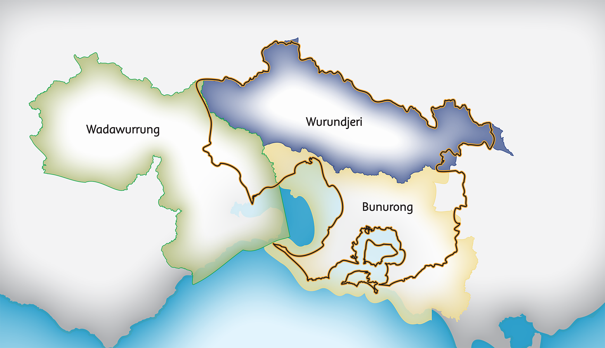
Indigenous settlement: The Indigenous Australians, specifically the Wurundjeri and Bunurong people, have inhabited the region surrounding Port Phillip Bay and the Yarra River delta for over 40,000 years.
1801: European exploration began with the arrival of Lieutenant John Murray on HMS Lady Nelson. He named the area Port King, later renamed Port Phillip Bay.
1835: European colonization commenced with the arrival of John Batman and John Pascoe Fawkner, who established the city of Melbourne along the Yarra River.
Indigenous Culture and History
The Aboriginal History of Yarra | Wurundjeri-willam - Kulin Nation
First Peoples local history and culture - City of Port Phillip
Kulin people accumulate the knowledge about the bay over many generations, including of its waters, tides, coast, plants, fish, and animals.
Western science is slowly catching up with this knowledge, including about how the Bay was formed.
On the formation of the bay, this is the story by Aunty Carolyn Briggs.
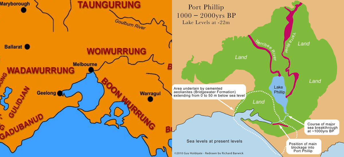
Flood causes Port Phillip Bay to form
The Indigenous Australians practiced sustainable land management techniques such as controlled burning, which maintained the area's biodiversity and preserved resources.
The Wurundjeri people's traditional lands extend across the Melbourne region, including the Yarra River and its tributaries.
Archaeological evidence: Dating back tens of thousands of years, archaeological sites in the region provide insight into the Wurundjeri people's way of life before European contact. Some of the key sites include:
-
Keilor Archaeological Site: Located on the Maribyrnong River, the site dates back around 31,000-40,000 years ago. It contains evidence of human occupation, including stone tools, bones, and hearths.
-
Green Gully: Situated in the Melbourne suburb of Keilor, this site dates back approximately 30,000 years and holds stone tools and other artefacts.
-
Kow Swamp: Although outside the traditional Wurundjeri territory, Kow Swamp in Northern Victoria contains remains dating back 19,000-26,000 years ago, offering valuable information about the broader Indigenous population in the region.
Environmental evidence: The climate and environment during the pre-European period influenced the Wurundjeri people's lifestyle. The last ice age, around 20,000 years ago, lowered sea levels and led to a colder, drier climate in the region. Around 14,000-10,000 years ago, the climate warmed, and the sea levels rose, shaping the landscape into its current form.
Persistence through Environmental Changes
Last Ice Age (approx. 20,000 years ago): The Last Glacial Maximum occurred around 20,000 years ago, resulting in lower sea levels and a colder, drier climate in Australia. The landscape would have been significantly different from today, with more extensive land areas exposed due to the lower sea levels.
Adaptation to environmental changes
The Wurundjeri people would have had to adapt to the changing environment during the ice ages. The colder and drier climate would have impacted the availability of food and water sources, requiring adjustments in their hunting, gathering, and land management practices. They might have relied more on terrestrial animals and plants for sustenance, as marine resources could have been scarcer due to the lower sea levels.
Changes in the landscape
As the ice sheets retreated and the climate warmed, the sea levels began to rise, leading to the gradual flooding of the region. This transition occurred around 14,000-10,000 years ago, shaping the landscape into its current form, including the formation of Port Phillip Bay. The Wurundjeri people would have experienced these changes in their environment and adapted their way of life accordingly.
Cultural continuity
Despite the environmental challenges posed by the ice ages, the Wurundjeri people maintained their cultural heritage, knowledge, and practices. This cultural continuity is evident in their Dreamtime stories, language, art, and land management practices.
European colonization and its impact
The arrival of European settlers led to deforestation, land clearing, and the introduction of non-native species, significantly altering the local ecosystem.
The Gold Rush in the 1850s caused rapid population growth and development, which put further pressure on the environment.
20th century to today:
Industrialization and urbanization during the 20th century led to increased pollution, including the Yarra River's contamination.
Since the late 20th century, efforts have been made to restore and protect the region's ecosystems. The creation of parks and reserves, such as the Port Phillip Bay Marine Park, aims to preserve natural habitats and promote sustainable land use.
In recent years, conservation efforts have focused on addressing climate change, preserving biodiversity, and restoring the water quality of the Yarra River.
Future
The future of Port Phillip Bay will be significantly influenced by factors such as climate change, urbanization, and environmental management. Here are some predictions and associated evidence for the bay's future:
Issues
Sea-level rise
Climate change is causing global sea levels to rise due to the melting of ice caps and glaciers and the thermal expansion of seawater. The Intergovernmental Panel on Climate Change (IPCC) has projected that global sea levels could rise by 0.26-0.77 meters by 2100 under different greenhouse gas emissions scenarios. This sea-level rise could lead to increased coastal erosion, flooding, and saltwater intrusion in the Port Phillip Bay area.
Coastal infrastructure and development
As the population around Port Phillip Bay continues to grow, urbanization and coastal development will likely increase. This could have various environmental impacts, such as habitat loss, water pollution, and increased pressure on local ecosystems. Planning and management will play a crucial role in balancing development with environmental preservation.
Water quality and pollution
The Yarra River, which flows into Port Phillip Bay, has historically faced water quality issues due to industrialization and urbanization. While efforts have been made to improve water quality in recent years, maintaining and further enhancing water quality will remain a priority for the bay's future. This will involve managing stormwater runoff, wastewater discharge, and litter to minimize pollution entering the bay.
Biodiversity and ecosystem health
The health of the ecosystems within Port Phillip Bay is critical for maintaining biodiversity and supporting local communities. Climate change, pollution, and other anthropogenic factors could lead to changes in marine habitats, species distribution, and ecosystem functioning. Conservation efforts, such as the establishment of marine parks and reserves, will play an essential role in protecting and preserving the bay's ecosystems.
Community engagement and stewardship
The long-term health of Port Phillip Bay will depend on the engagement and stewardship of local communities, including Indigenous communities with deep connections to the area. Encouraging sustainable use of resources, promoting environmental education, and fostering partnerships between governments, scientists, and community groups will be vital for protecting the bay's future.
Plans and Scenarios
Port Phillip Bay Environmental Management Plan (EMP): The Victorian Government developed the EMP to guide the long-term planning and management of Port Phillip Bay. The plan includes strategies to protect the bay's environmental values, promote sustainable use of resources, and enhance community stewardship. The EMP outlines various scenarios and management responses to address issues such as climate change, water quality, and habitat protection.
Yarra River 50 Year Community Vision: Melbourne Water, in collaboration with the Yarra Riverkeeper Association and the Wurundjeri Woi Wurrung Cultural Heritage Aboriginal Corporation, developed a long-term vision for the Yarra River (Birrarung) and its surrounding landscapes. The vision outlines scenarios and strategies for managing the river's health, improving water quality, and protecting cultural and environmental values.
Western Port Integrated Water Management Forum: This forum, coordinated by Melbourne Water, brings together various stakeholders to develop integrated water management strategies for the Western Port region, which includes brackish waters near Melbourne. The forum focuses on long-term scenario planning and developing collaborative solutions to manage water resources, protect ecosystems, and enhance community wellbeing.
The Ramsar Wetlands in Victoria Strategy: This strategy provides a framework for the management of Ramsar-listed wetlands in Victoria, including the Western Port Bay and other brackish waters around Melbourne. The strategy outlines long-term objectives, such as maintaining the ecological character of the wetlands, supporting habitat connectivity, and ensuring sustainable use of resources.
Data Sources
-
DELWP MapShare - Department of Environment, Land, Water and Planning (Victoria, Australia) is a key source of geospatial data for Victoria, including Port Phillip Bay. They provide datasets related to land use, vegetation, topography, and more. You can access their data through the Victorian Government Data Directory or the DELWP MapShare portal.
-
Geoscience Australia. As the national agency for geoscience research and geospatial information, Geoscience Australia offers a wide range of data, including elevation data, satellite imagery, and geological data. Some datasets, like the National Elevation Data Framework (NEDF), include LiDAR data.
-
AODN Portal. Australian Ocean Data Network (AODN): AODN provides access to oceanographic and marine data, including bathymetry and seabed mapping for areas like Port Phillip Bay. They offer a user-friendly portal where you can search and download datasets.
-
OpenStreetMap (OSM) is a collaborative, open-source mapping project that provides a wealth of geospatial data worldwide. Although it does not provide LiDAR data, it is a useful source for GIS data related to roads, buildings, land use, and other features in the Port Phillip Bay area.
-
Melbourne Water. As the regional water management authority for the Port Phillip Bay area, Melbourne Water is another potential source for GIS and environmental data. While they may not provide LiDAR data directly, they can offer useful information related to water quality, waterways, and catchments.
Relevant Reserach Projects
The Blue Carbon Lab: This research group at Deakin University focuses on understanding the role of coastal ecosystems in mitigating climate change. Their research explores the role of "blue carbon" ecosystems, such as seagrass meadows, saltmarshes, and mangroves, which are critical habitats for various species in the Port Phillip Bay area.
Reef Life Survey: This global marine life survey project, initiated by researchers from the University of Tasmania, involves citizen scientists in monitoring marine ecosystems, including those in Port Phillip Bay. By gathering data on species abundance and distribution, the project aims to understand the more-than-human aspects of these ecosystems and inform conservation efforts.
Law
Include other relevant/pluralist legal/normative regimes...
-
International Convention for the Prevention of Pollution from Ships (MARPOL)
-
Ramsar Convention on Wetlands is an international agreement focused on the conservation and sustainable use of wetlands. While there are no Ramsar-listed wetlands within Port Phillip Bay, the Western Port Bay, which is nearby, is a designated Ramsar site. The principles and objectives of the Ramsar Convention may still influence the management of wetlands and coastal ecosystems in the Port Phillip Bay area.
References
Frankel, David. Between the Murray and the Sea: Aboriginal Archaeology of Southeastern Australia. Sydney: Sydney University Press, 2017.
Dovey, Kim. Fluid City: Transforming Melbourne’s Urban Waterfront. Sydney: University of New South Wales Press, 2005.
Corrigan, Colleen, Heather Bingham, Yichuan Shi, Edward Lewis, Alienor Chauvenet, and Naomi Kingston. ‘Quantifying the Contribution to Biodiversity Conservation of Protected Areas Governed by Indigenous Peoples and Local Communities’. Biological Conservation 227 (2018): 403–12. https://doi.org/10/gj84hb.
Footnotes
Holdgate, Guy R., Barbara Wagstaff, and Stephen J. Gallagher. ‘Did Port Phillip Bay Nearly Dry up Between ∼2800 and 1000 Cal. Yr BP? Bay Floor Channelling Evidence, Seismic and Core Dating’. Australian Journal of Earth Sciences 58, no. 2 (2011): 157–75. https://doi.org/10/b6fnnb.˄
Backlinks